 |
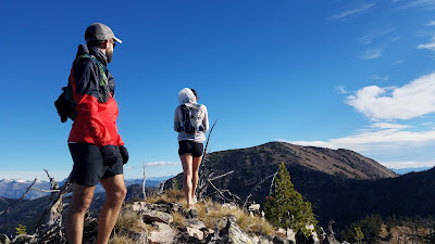
| Looking at McLeod |
I met Nate Bender and Kristina Pattison at the main Rattlesnake Trailhead a mere week after the Rut Mountain Runs. We were all still tired from the race, but decided to try a long traverse of the entire Rattlesnake ridgeline, from McLeod down to Stuart Peak. Kristina would join us for first portion, up Finley Creek, climb McLeod, then back down Finley Creek where her car was waiting, while Nate and I continued South back towards Missoula and our vehicles.
 |
| Finley Lakes Trail |
The morning air had a bite to it. Snow still clung to north facing slopes and freezing overnight temperatures kept it from melting. We all started off in jackets, but as the trail, and our effort level rose, we peeled layers.
The path up Finley Creek made for entertaining running. None of us had explored the drainage before and we found it difficult to look around and still keep our footing on the twisting trail. I stubbed my toes multiple times in the first few miles and each kick brought my focus back to the trail for a few minutes before I would get distracted again.
Finley is a popular ice climbing destination for Missoula area climbers. With five or six established routes - including the aptly named Thing In Between, which is easy to discern even without ice - and relatively easy access, there may be more winter use of Finley Creek than summer (results based on a completely accurate sample survey of 2 users, myself and an ice-climbing co-worker. I went there once in the summer, he went twice in the winter, ergo more popular in the winter).
 |
| First view of McLeod Peak |
A few miles up the trail we took a slightly visible path up a scree field into another drainage. This would bring us closer to the summit of McLeod and reduce our out-and-back portion of the ridge. Leaving the trail to Finley Lake meant that we were off any sort of official or obvious trail for the next few hours. The initial off trail section involved some annoying side-hilling, but with three sets of eyes we managed to hop from game-trail to game-trail and avoid too much ankle breaking hiking.
Soon enough the terrain filled with scree and we alternated between rock-hopping and traveling parallel to the base of the rocks. As the rim of the drainage on our left began to drop closer I began to feel the call to get up on the ridge. We waited another mile or so, but then I saw a place that looked like a good access point to the top. Generally ridgelines and shoulders, at least in my previous experience in the Rattlesnake, make for quicker moving than bushwhacking in the valleys. When we reached the top of the spit connecting to the main ridgeline, I realized the northern reaches of the Rattlesnake are markedly different from my previous adventures. Immediately the ridge narrowed down and we had to pick our way through a few Class 3 sections in increasingly blustery winds and a few lingering snow patches. So much for faster moving.
 |
| Last push to the summit |
McLeod loomed to the north, and the snow covered Missions behind, and the blue skies held the promise of an excellent view from the summit. After maneuvering over the more technical bits of the spit, we hit the main ridge and turned left to head for the summit. The broader ridge here allowed for a few sections of short running, but when we began the final push we fell back to a hike.
Though our pace slowed, the wind picked up, and by the time we reached the top of the highest point in the Rattlesnake Mountains, the wind was fierce. The excellent view I expected was obscured by the wind tears in my eyes. Running shorts seemed rather foolish at this point in the day.
 |
| On the windy summit of McLeod Peak, high point of the Rattlesnake |
Since we had all done the Rut, which involves running through scree, we could not resist the temptation to race the scree field off of the summit and we quickly found ourselves back less-windy ridgeline heading back the way we came. Soon Kristina peeled off and dropped back down the drainage to her car and preparing for a Sky Race in Europe, and Nate and I continued on.
 |
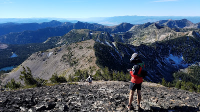
| Descending McLeod and looking at the long ridge yet to be traversed. |
The second, more southern tooth provided an unobstructed view of the rest of our route to Stuart Peak and the more familiar sections of the Rattlesnake. Looking at the ridge we decided dropping to Sanders Lake for a water refill would be wise, plus that route looked more fun. The ridge made a secondary, bowl-shaped ridge that encompassed Sanders Lake, and we thought running the bowl would be a great way to get more technical travel in, which we both not-so-secretly yearned.
The traverse to Sanders was a pleasant jaunt through sparsely treed terrain before giving way to broken buttresses that had been hidden from our viewpoint on the ridge. Each buttress kept trying to push us farther downhill when we wanted to be on top of them to avoid dropping below the elevation of Sanders Lake so we clambered up each little rise and before long caught a glimpse of the lake immediately below us.
 |
| Sanders Lake viewpoint with Mosquito and Stuart on the horizon |
Like all the lakes we saw in the Rattlesnake that day, Sanders Lake is dammed. In the early days of Missoula, circa 1880, the upper Rattlesnake was dotted with over 100 homes. Dams were built on all the upper lakes to create a year-round steady flow of water down Rattlesnake Creek, the main water source for burgeoning Missoula. The control kept the creek from flooding out new homes in the spring runoff, and drying up in the drought of late summer.
The dam at Sanders Lake changed where outlet stream cascaded out of the lake. We picked our way down and up the original drainage, now barren, then ran along the dam to the current spillway, which dropped a couple hundred feet to Wrangle Creek, a short tributary of Rattlesnake Creek. After a short lunch, water refill, and successfully fighting the urge to take a nap in the sun, we were back on the move.
 |
| Leaving Sanders Lake and climbing toward Mosquito Peak (left) |
In this section the ridge splits. One fork heads off towards Murphy Peak, Point 6 and ultimately the Snowbowl Ski Area, and the other fork, which we followed, continued on to Mosquito Peak, Stuart Peak, and the Main Rattlesnake Trailhead. After the fork pieces of common use trails began to appear making travel easier. Not many people venture this far back in the Rattlesnake, but most of those who do travel from Snowbowl to Stuart creating another route with a car shuttle.
 |
| 25 miles, 9,000' of climbing |
A short side trip put us on the top before we followed the ridge line again back to the trail. Being back on trail immediately caused me to feel more tired. I felt ready to begin the long descent, we just had one more mountain.
From the top of Stuart Peak we could look back north along our entire traverse from the day. McLeod Peak dominated the horizon of the Northern Rattlesnake, the two gendarmes (shark teeth) protruded just south of there, and even Mosquito Peak looked far away. We covered a lot of ground that day, and still had nine miles to go.
By the time we reached the cars after the long Stuart Peak Trail descent we were both properly exhausted. We did 25 miles with over 9,000' of climbing, mostly off trail, a week after the Rut and didn't get hurt. Exhaustion felt well earned.
Comments
Post a Comment