 |
| Looking down on Kent Lake from Kent Peak |
Possibly because of the lack of cliff faces, the Sapphires have been heavily logged over the last century so the mountains are criss-crossed with numerous roads and road beds. Parts that weren't logged, or were logged and grew back, have burned. The lack of old growth forest, though, has created an incredible habitat for deer, elk, and moose, all of which are plentiful in the range. With easy road access and a fairly extensive trail system the Sapphires are ripe with hunters every fall. There, habitat for large mammals is good enough to support herds that can survive heavy hunting, and support at least two growing wolf packs. Open meadows, remnants of burns and logging, provide excellent habitat for ungulates, and spots for humans to sit and look at stuff.
 |
| Meeting up with the 313 Trail |
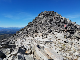
From the trailhead to the summit is only four miles, but the last mile of that traverses a rocky, talus strewn ridge (at least the way we chose to go). Sara, her friend Brie, Zeno (our dog), and I set out from the car just before noon and quickly covered the first few miles of gentle climbing. Initially the trail followed an old road bed but the veered away from it, skirted two ponds, and then reached the junction with the 313 trail. The 313 trail itself deserves exploring as it hugs the Sapphire Divide and runs nearly the 85 mile length of the range.
 |
| With Zeno just below the summit |
The Sapphires represent the trailing edge of an ancient batholith rock crust that broke away from Idaho and moved into Western Montana. According to David Alt and Donald Hyndman's Roadside Geology to Montana the 10 mile thick crust took a few million years to migrate over the border. During those millions of years it folded the earth in front of it to help create the Garnets, the Flint Creek Range, the Anacondas, and the Sapphires. The folding combined with later upward lava seepage created the mold from which glaciers carved the mountains years later. The Bitterroot Valley on the western edge of the Sapphires represents the end of the traveling crust and the sloping western edge of the Bitterroot Mountains still bears the marks of the batholith crust grinding and sliding its way along its path.
We didn't know if the rocks we picked our way through on the ridgeline to the summit were from the original Idaho crust, or from later lava seepage, but we did know it slowed us down a bit. Still the sun was out, the air was surprisingly clear for August in Montana, and we were having a good time. Picking routes was like a puzzle for me. I had to be careful not to lead on routes that would leave my shorter leg compatriots stranded, and Zeno made it clear he preferred to be on more level rocks.
 |
| Brie and I on the last stretch to the top |
From the top of Kent Peak, the Bitterroots and the Anaconda Range looked especially close. It looked like we could just hike over to East or West Pintler Peak by that evening if we desired. Driving around the state to get into these mountain ranges makes them feel farther apart than they actually are.
From the summit we picked an alternate route down that would limit our time on the rocks. Zeno was moving fine on dirt surfaces, but was struggling on the rocks. We realized we could drop straight off the west face of the peak down to Kent Lake and then try to pick up the 313 trail. The only obstacle was a 1,000' drop over the same type of large talus boulders we traversed on our ascent.
 |
| On top of Kent Peak |
Sara and Brie seemed to be enjoying themselves heading down the slope with great views of the Bitterroots in front of us and a lake at our feet. I missed most of it, however, because I was intently focused on each step. Occasionally I set Zeno down to take a break, but otherwise we kept moving. After only one spill we hit soft dirt and Zeno was back to bouncing around trying to chase squirrels.
We took a quick dip in Kent Lake then crossed through a burn area and picked up the trail on the ridgeline. After another mile we were back on our ascent trail and headed downhill toward the car.
 |
| Carrying Zeno down to Kent Lake |
Montana Mountain Project - Peak 10/64
how did you get the mileage as 4 miles one way? My map program measures this consistently as 10 miles one way via skalkaho creek trails and 8 miles one way from the upper trailhead.
ReplyDeleteThe road to the trailhead is pretty smooth as far as roads go for driving...but it is a pretty big challenge on a bicycle! At least, I assume it is, I've never bicycled it more than about 5 miles in! :)
ReplyDelete